This map was derived from my ArcGISPro original, exported to Adobe Illustrator for cartographic enhancements not available within ArcGIS Pro, particularly with respect to the placement of labels.
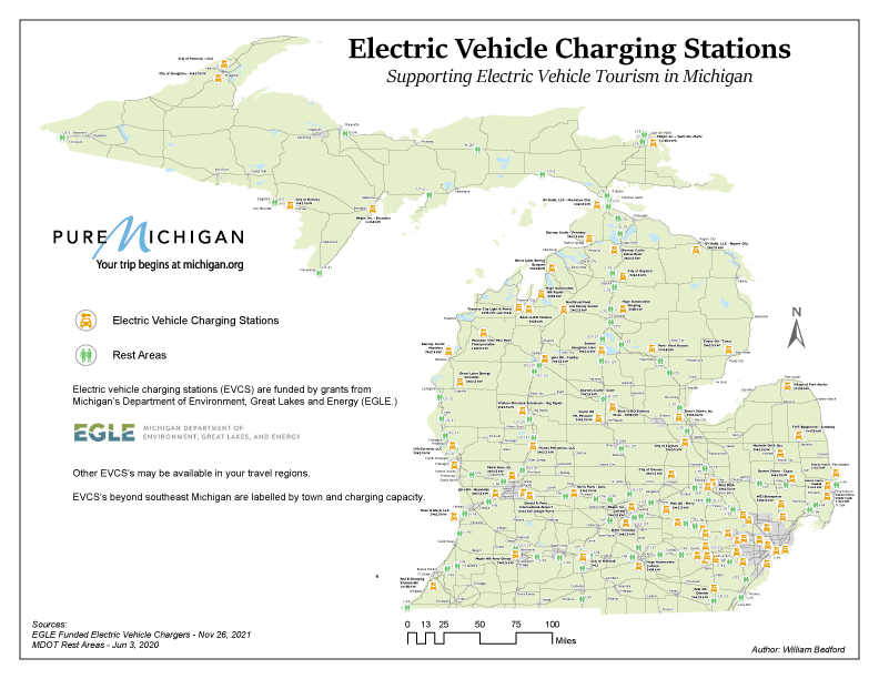
Michigan’s Department of Environment, Great Lakes and Energy (EGLE) has undertaken a grant program to fund locations throughout the state with the establishment of electric vehicle charging stations. The grant program is a nod toward to a governmental vision for supporting the electric vehicle travel mode, taking shape in the ‘now.’
Some of these ‘stations’ are in familiar community destinations like grocery stores or city buildings, but are not normally associated with vehicle ‘fueling.’
Most of these stations are in non-traditional sites, like local fuel wholesalers, or industrial fueling sites that are not normally associated with personal vehicle fueling.
It’s a future that is certainly going to take some ‘getting used to!’
Design Goal
Establish a visual hierarchy emphasizing point locations of EGLE funded electric vehicle charging stations in-relation to Michigan highway rest areas. The design imagines a tourist, having stopped at any rest area, might be relieved to find their next electric vehicle charging station nearby, and take a copy as a future reference while they travel longer distances throughout the state.
Other considerations were to design a base map style that might suit itself to a series of themed maps, with different topics i.e., trails-by-type, public facility locations, etc.
Typestyle Choices
Gill Sans for cities
Gill Sans for rest areas
Gill Sans Display Bold for electric vehicle charging stations
Sitka for the title and subtitle adds a touch of panache.
Use of Color
In Symbols – Nominal scheme, orange for electric vehicle charging stations, green for rest areas.
In Typography – Black with white halos.
In base map – Single color fill, light green.
Color Blindness considerations – Symbols use distinctive, black circles and graphic shapes as their primary identifiers. Color is supportive, but less important. Anyone with color-blindness will be able to leverage the graphic shapes to interpret the map
Use of Symbols – Graphic and Typographic
Rest Areas – standard men/women bathroom symbol in ArcGIS Pro
Electric Vehicle Charging Stations – standard vehicle starting symbol in ArcGIS Pro
Map Elements & Layout
– Frame line & Neat line – 8.5 x 11 Landscape.
– Mapped area – State of Michigan, not including Isle Royale. Isle Royale is not included due to no vehicular traffic on the island. Including it would also force an even smaller scale map, which is already a challenge in this design.
– Visual hierarchy –
Title
Subtitle
Symbols – Electric Vehicle Charging Stations
Symbols – Rest Areas
Symbols – Urban Areas & Towns
Symbols – Towns
Labels – Electric Vehicle Charging Stations
Labels – Rest Areas
Labels – Towns
Base map
– Inset map – Not applicable, though the urbanized southeast region could be treated as a larger scale inset to achieve labeling of electric vehicle charging stations. The title says the design intent is to display electric vehicle charging stations for traveling longer distances than in the southeastern urban region.
– Insets – Selected photos and/or a drive-time table (Elected not to implement these ideas.)
– Title and subtitle – Michigan – Rest Areas and Electric Vehicle Charging Stations
– Legend – Rest Areas and Electric Vehicle Charging Stations
– Footnotes:
Map design, production and distribution is funded by Pure Michigan.
EVCS’s displayed on this map were funded by the Michigan Department of Environment, Great Lakes and Energy. Other EVCS’s may be available in your travel regions.
EVCS’s beyond southeast Michigan are labelled for long-distance planning.
Data sources: MDOT Rest Areas – Jun 3, 2020, 12:09; State Owned Roads – Dec 3, 2021, 13:40; Cities – Dec 3, 2021, 12:44; EGLE Funded Electric Vehicle Chargers – Nov 26, 2021, 23:36; Counties_(v17a) – Dec 4, 2021, 17:43; michigan_coastline
