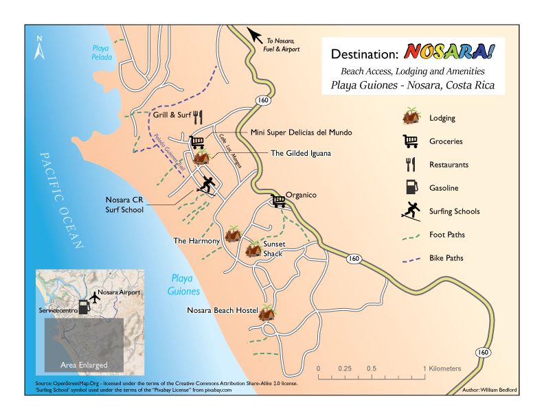
Beach Access, Lodging and Amenities – Playa Guiones – Nosara, Costa Rica
Design Goal
The map sets out to craft a cartographic improvement over an existing map that is available in the region, below:

It seeks to provide improved symbology, layout, legibility and readability. The basic design is intentionally limited to showing only ten of the many features in the region, but lends itself to the addition of similar reference information in future revisions.
Typestyle Choices
Gill Sans variations are used throughout the map. It’s san serif design is consistent with a typographic tradition in cartography of using san serif typestyles for cities and regional features. It’s letterforms are easy to read and strong enough to stand on their own visually in the midst of other cartographic elements. Nothing fancy here, just strong, basic cartographic typography.
Sitka is used in the ocean label and in the title block to add a bit of elegance and emphasis.
Forte is used in the title for the name ‘Nosara’ to add a touch of celebration.
Use of Color in Typography
Color and effects have been employed consistently on a feature-type basis, selected for cartographic traditions. Where visual hierarchy imbalances occur with consistent use of color and effects, subtle differences in hue and lightness have been applied to correct visual hierarchy.
The colors of the rainbow, ‘ROYGBIV,’ have been used sequentially in the letters of the name ‘Nosara’ to add another touch of celebration and excitement.
Use of Symbols – Graphic and Typographic
Symbols, both custom and standard from Illustrator have been employed to identify selected features.
Map Elements & Layout
– Frame line & Neat line – 8.5 x 11 landscape orientation.
– Mapped area – The Playa Guiones area within the Nosara region of Costa Rica
– Visual hierarchy –
Title
Subtitle
Symbols – Lodging
Symbols – Amenities
Symbols – Beach access via foot and bicycle
Labels – Lodging
Labels – Amenities
Labels – Road names
Basemap – Developed from references to Nosara, Costa Rica from OpenStreetMap
– Inset map – Small-scale regional map, showing enlarged area, and symbols for gas and airport that lie outside the enlarged area.
– Legend – Depicts all symbols except ‘Airport’
– Licensing – Noted appropriately with reference to the surfing school symbol and the inset map.
– Data source and author – OpenStreetMap_Base_CyclOSM; https://www.diva-gis.org/datadown, Coastline, Roads, Gazetteer; https://mapcruzin.com/free-costa-rica-country-city-place-gis-shapefiles.htm: This ArcGIS shapefile is extracted from CloudMade data, derived from OpenStreetMap and is licensed under the terms of the Creative Commons Attribution Share-Alike 2.0 license. It is made available here by MapCruzin. If you use these files please make sure you attribute the OpenStreetMap community and MapCruzin by including a link to http://www.openstreetmap.org and http://www.mapcruzin.com. If you alter, transform, or build upon this work, you may distribute the resulting work only under the same or similar license to this one. Find out more about Creative Commons licenses at http://www.creativecommons.org.
– Scale – Graphic scale bar – Set in kilometers as a nod to the local environs. This may challenge the American target audience to a small extent, but the metric system has been taught in American schools for decades, and a teensy challenge for a ‘world traveler’ is not out-of-order.
– Use of Color (Lightness, hue, saturation, black and white conversion, color-blindness consideration.) – The use of unique graphic shapes in the symbols gives a color-blind reader access to the information in the event of inability to distinguish between colors.
– Spacing/texture – Blending has been used to accent and emphasize the beach and coastline.
